| Location | Subdury, ON – 10 km off Trans-Canada Highway |
| Target | Gold | IOCG | Magmatic Copper-Nickel-PGE | Silver | Cobalt | REE |
| Area | 197 sq.km. |
| Ownership | 100% |
Overview
The SPJ Gold Project is a polymetallic (Gold, IOCG, Copper-Nickel-PGE, Cobalt, Silver, REE) project located 40km east of the prolific Sudbury Mining Camp.
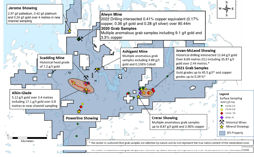
Our 197 sq.km. land package covers three townships and includes the past-producing, historic Scadding Mine, which produced 29,000 oz of gold at a head grade of 7.2 g/t.
Successful exploration in the Scadding Township was first reported in 1891 and since then has reported several high-grade gold deposits. However, this polymetallic gold district area remains substantially underexplored and with modern, systematic exploration techniques has significant upside potential
The SPJ Gold property features numerous gold showings and hosts several past producing mines. Our goal is to focus on both expanding on the mineralization discovered and connecting a large gold system on our property.
Phase 1 Exploration Approach:
Our 2022 preliminary exploration program began with the collaboration between Macdonald Mines Exploration and GoldSpot Discoveries, a mining- focused technology company applying cutting edge Artificial Intelligence algorithms to significantly increase the efficiency and success rate of mineral exploration.
GoldSpot was engaged to apply their proprietary machine learning applications and geoscience expertise to assist in expanding current discoveries and identifying new high-priority target areas on the SPJ Property
Highlights of the Macdonald Mines-GoldSpot Discoveries collaboration include:
- 53 priority exploration targets identified on the SPJ project including five areas of high priority
- Three high priority areas, Glade, Alwyn and McLeod, correspond to high priority targets identified by the MacDonald Mines exploration team over the last year and a half for their gold and polymetallic gold potential
- Goldspot’s AI and geoscience work indicate that the Alwyn, Glade and McLeod targets are extending over strike length between 1 and 3 km
- 2 new areas identified by GoldSpot as high priority areas, including the Scadding Trend and Pine (See Figure 1 Below)

Figure 1: GoldSpot generated targets at the SPJ Property. Highest priority in red, medium priority in orange and lowest priority in green. The SPJ Property is shaded in pale blue, interpreted structures in dark blue lines.
Through the compilation of historic data, previous drilling campaigns and interpretation of the GoldSpot collaboration results, Macdonald Mines has announced a Phase 1 Exploration Program which consists of up to 1500m of oriented diamond drilling at the high priority Alwyn Mine (Au-Cu) and Glade (Au) targets (Figure 1).
Phase 1 Drilling Results:
Alwyn Mine Cu-Au Target
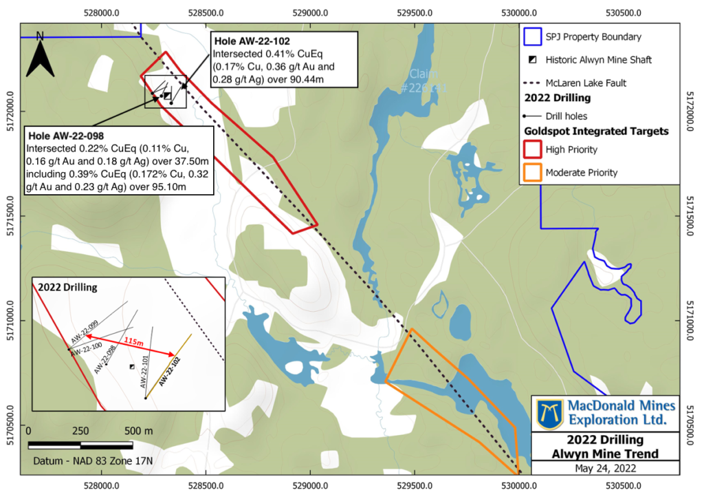
- 696m of oriented diamond drilling in 5 drillholes completed in May 2022
- Potential copper-gold mineralization confirmed over a strike length of 115m and remains open in all directions
- Strongest quartz veining, alteration and mineralization intersected east of the Alwyn Mine (hole AW-22-102) where the high-priority target of GolSpot’s further extend south for 1.5 km
- Hole AW-22-102 intersected 0.41% CuEq (0.17% Cu, 0.36 g/t Au and 0.28 g/t Ag) over 90.44m including two zones of stronger mineralization
- Upper Zone: 41.53m at 0.53% CuEq (0.24% Cu, 0.43 g/t Au and 0.41 g/t Ag) including 3.99% CuEq (1.36% Cu, 3.87 g/t Au and 3.05 g/t Ag) over 3.20m
- Lower Zone: 13.00m at 0.84% CuEq (0.29% Cu, 0.82 g/t Au and 0.33 g/t Ag)
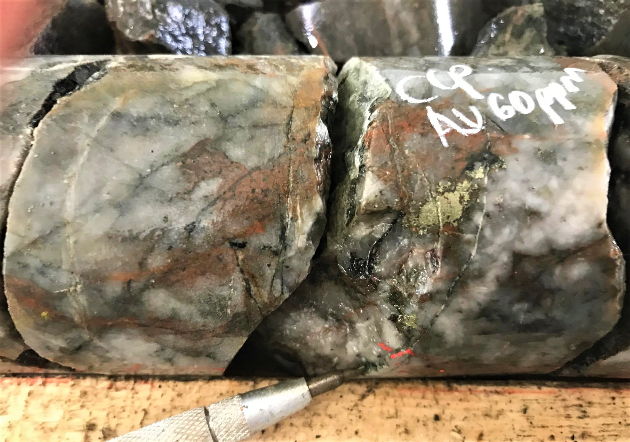
- Intersection in four of the five hole completed in the Alwyn Mine area, of broad intervals (30-116m – core length) containing up to 2% chalcopyrite, traces of bornite and variable pyrite
- Sulfide mineralization associated with multi-directional networks of quartz-carbonate to carbonate veins representing an average of 5-10% of the mineralized zones
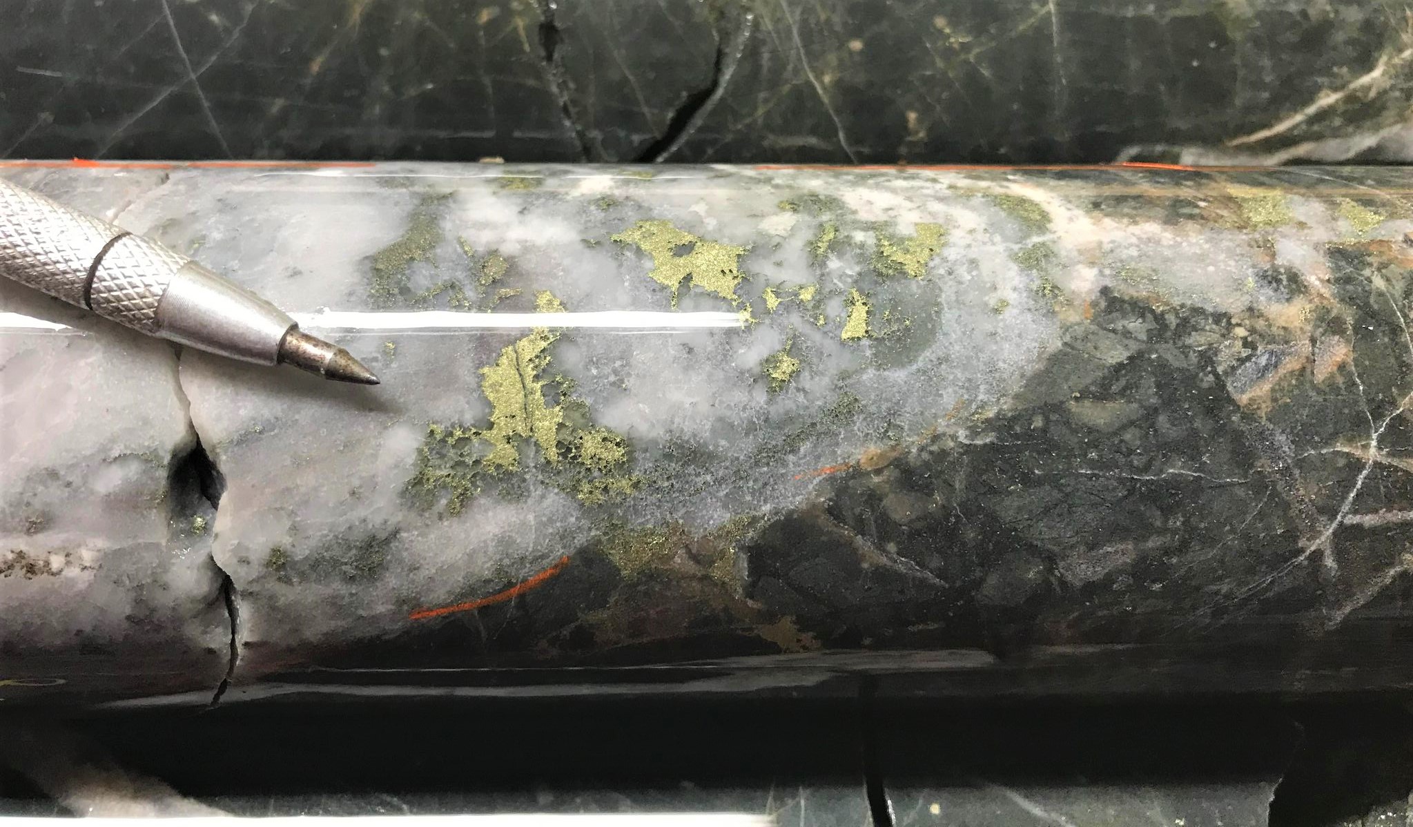
- Specular hematite is observed in some holes (See Below) within fractures of mineralized veins and
commonly occurs as halos surrounding sulphides in veins - Strong potassic and sodic alteration halos are commonly associated with broad zones of mineralization and veining
Glade Area:
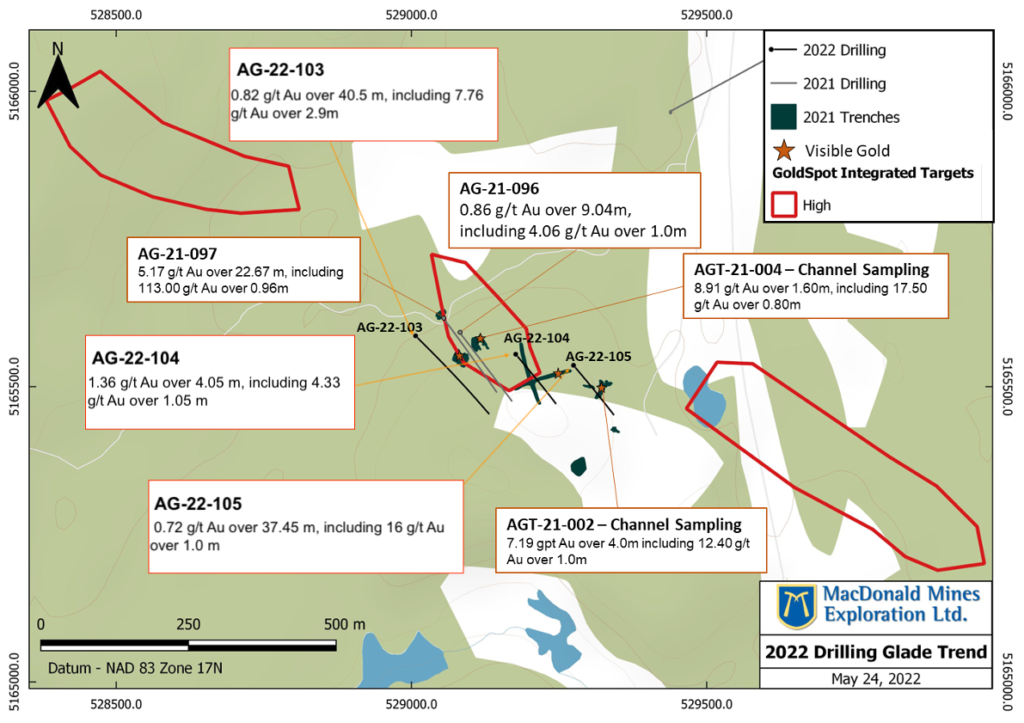
- 503m of oriented diamond drilling conducted over 3 drill holes to follow up on successful 2021 drilling and trenching results.
- GoldSpot’s high-priority Glade Trend has a strike length of approximately 1.7km
- Visible gold observed in all three holes drilled during 2022.
Alwyn Mine Area:
- The historic Alwyn Mine is located in the North Western portion of our SPJ Land Package. Past production by Alwyn Porcupine Mines Ltd. (1950-1959) included 7000 tons @ 5.67 g/t Au and 1% Cu.*
- The Alwyn Mine discovery featured Au-Cu-Ag mineralization in quartz-sulfide veins along the McLaren Lake Fault Zone, which is hosted by Gowganda formation sediments. Two historic drilling programs discovered significant assay results:*
- 1983 – Diamond Drilling Reported intersections of up to 1.38 g/t Au over 15.4m and up to 16.59 g/t Au over 1.52 metres and 4.46 g/t Au over 3.81 metres*
- 1950 – Diamond Drilling Reported intersections of up to 3.9 g/t Au and 0.79% Cu over 6.04m*
- The 2021 trenching/mapping program at Alwyn Mine confirmed the presence of two significant shear zones and of a dense network of Au-Cu bearing quartz-carbonate veining system at surface.*
- Based on GoldSpot’s machine learning targets, the zone of high exploration potential that corresponds at its northern end to gold-copper mineralization identified at surface at the Alwyn Mine could extend over a 2.5 km long NW trend. This trend is following the major McLaren Lake Fault, historically interpreted as the primary control on gold-copper mineralization at Alwyn Mine and the Ashigami Mine.*
- Oriented drilling will be conducted to confirm historic intercepts and to test the lateral extension of the gold-copper mineralized system identified at the Alwyn mine.*
*The reader is cautioned that the assay data is historical in nature, and the qualified person has not independently validated the accuracy of the historical results. The true width of the intersected zone of mineralization is unknown.
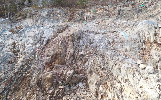
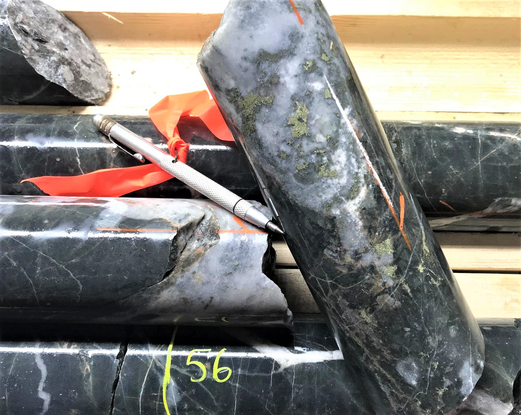
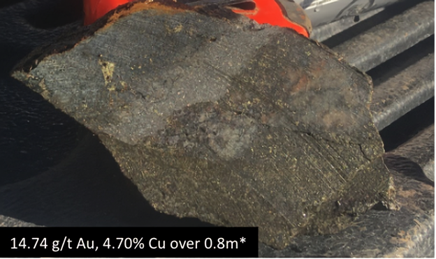
Shear Zone associated with Au-Cu mineralization at Alwyn Mine.

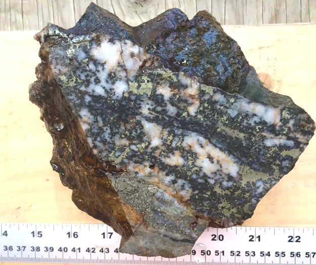
Grab samples illustrating Cu-Au-Ag mineralization associated with Qtz-Cb veining of the Alwyn Mine
Glade – Powerline Area:
- In the Glade Area, Ontario Geological Survey maps and historical exploration has identified a broad zone of disruption, alteration, deformation and mineralization that extend over a strike length of 300m. Furthermore, high-grade gold in quartz veins were reported historically.
- Our past drilling programs in the Glade Area were centered on the Glade West Showing identified in the 1930’s and 1940’s and prospected by Macdonald Mines in 2019 where grab samples returned up to 18.53 g/t Au.
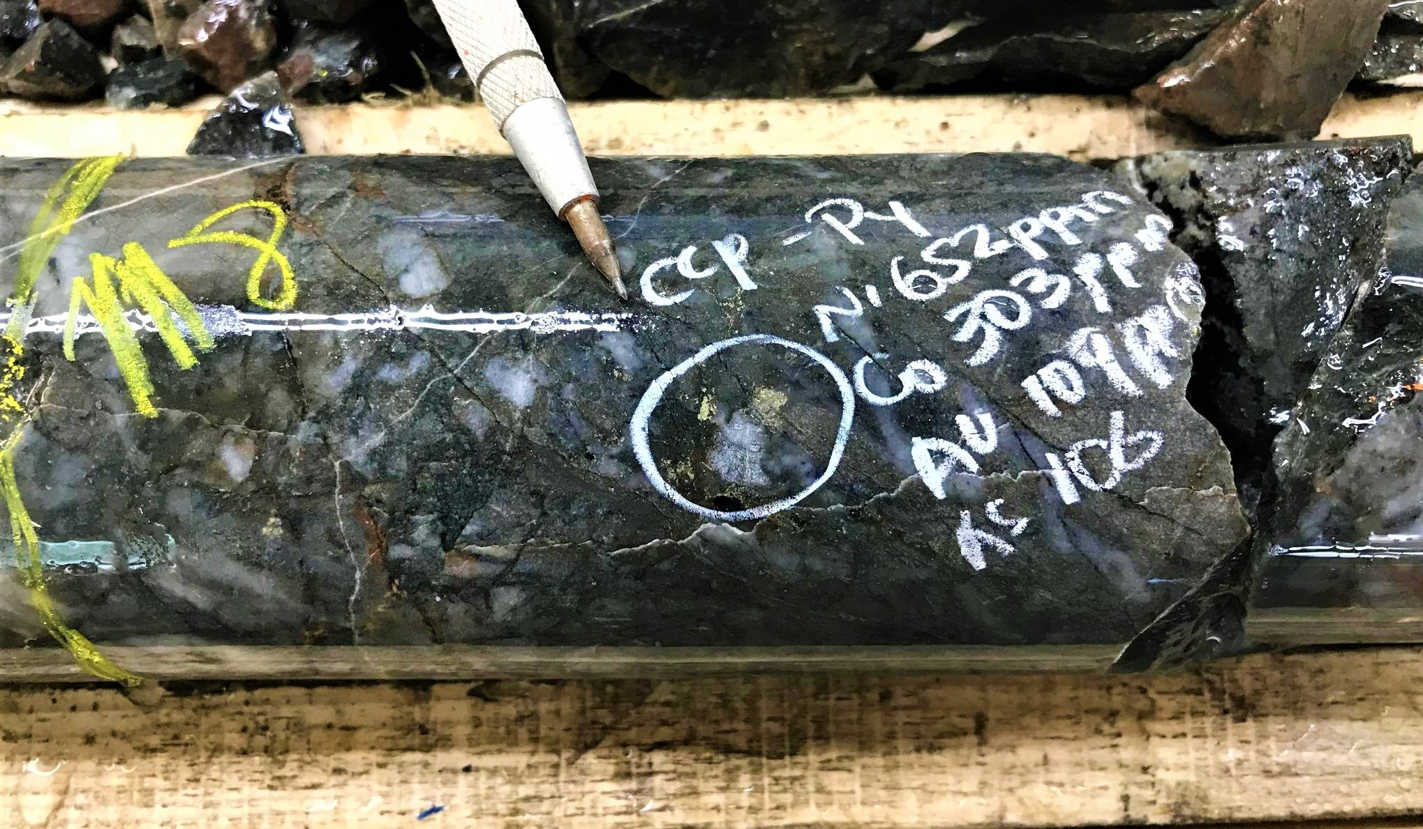
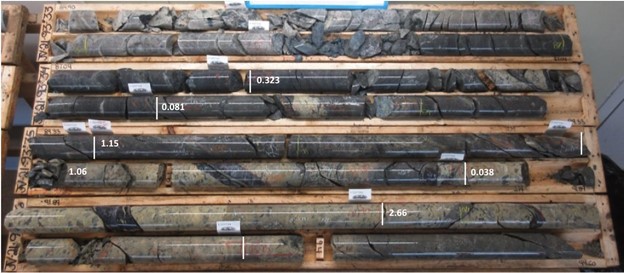
- Furthermore, our diamond drilling program completed in 2021 under the Glade West Showing in holes AG-21-096 and AG-21-097 revealed a large alteration and mineralized system where shear-hosted quartz veins are surrounded by networks of gold mineralized, multi directional and variable spaced quartz tension veins concentrated in the Nipissing intrusion.
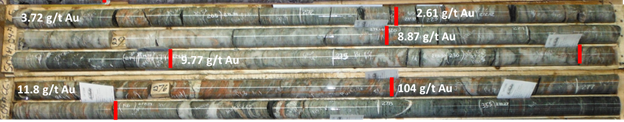
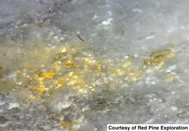
- Visible Gold was observed in many of the quartz veins in both holes AG-21-096 and AG-21-097. Assay results on Hole AG-21-097 returned 5.17 g/t Au over 22.67 m, including 113 g/t Au over 0.96m (See Below).
- In certain quartz veins, visible gold is associated with iron-rich chlorite alteration emplaced and crosscutting the quartz veins. This association between gold and iron-rich chlorite is similar to the association between iron-chlorite and gold at the Scadding Deposit.
- The potential relationship between the mineralization observed at Glade and the Scadding Deposit, just 800m north, potentially represents a considerable extension to that mineralized system.
- 2022 drilling at Glade will follow up on the successful drilling and trench work completed in 202. Mineralization appears to follow the upper and lower contacts between a Nipissing sill and Huronian sedimentary rocks, potentially spanning a 3km east-southeasterly trend, as indicated by GoldSpot’s targeting results.
The goal of this program will be to target high grade gold mineralization down plunge from the intercepts measured in quartz veining hosted in Nipissing diabase at surface.

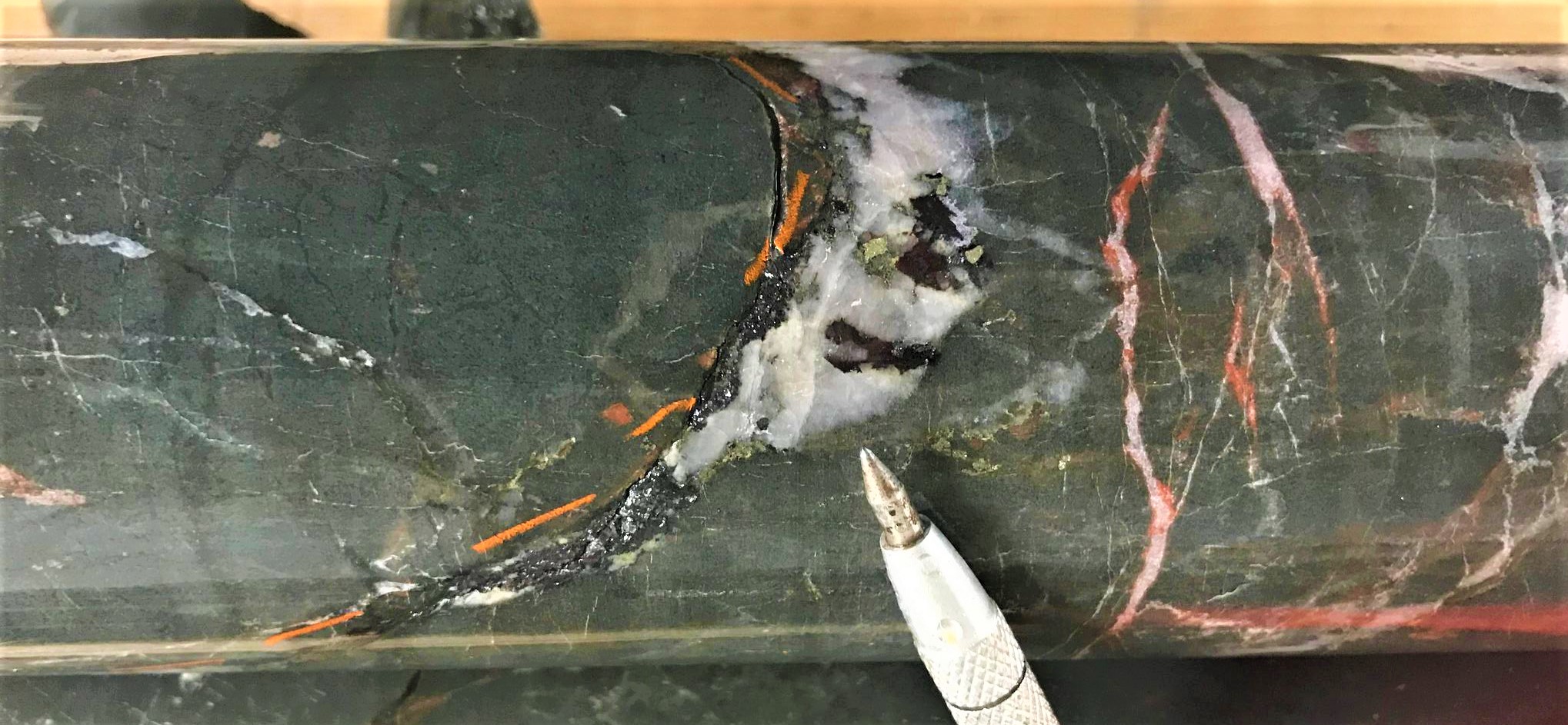
Glade Geological Formation and Visible Gold from Glade Showings
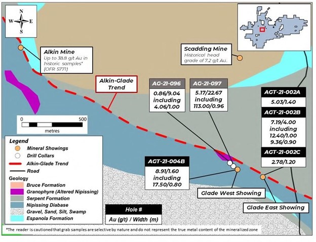
- Located less than 5 kilometres W-NW from the Glade showings is the historical Alkin Gold Mine. Gold Mineralization occurs as a network of quartz veins hosted in the Felsic phase of the Nipissing Diabase Intrusion that also hosts Glade showings.
- Reconnaissance work by the Ontario Geological Survey reported gold assays up to 38.8 g/t Au in grab samples taken from the veins exposed at the Alkin Mine (OFR 5771).
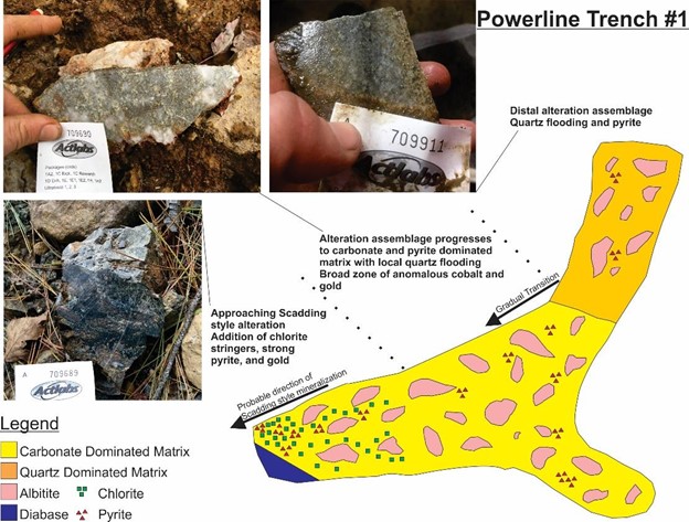
Powerline Area:
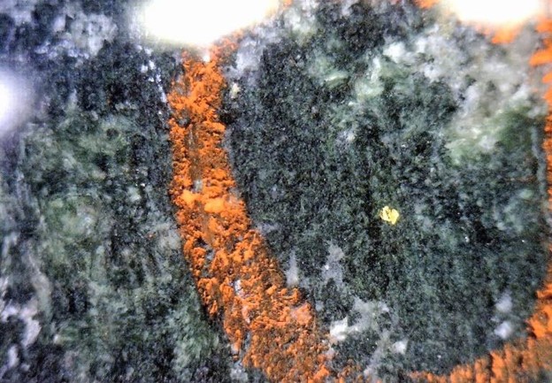
- The Powerline property area is located within a kilometre of the past-producing Scadding Mines. Channel sampling completed by our exploration team on the Powerline Property revealed a significant Co-Cu-Au anomaly in the bedrock that was exposed at surface with mechanized stripping.
- The mineralization that was discovered is hosted in a breccia zone that was exposed in a cross-shaped trench that was traced for over 50 metres along both segments of the cross, and along the edges of the trench.
- At certain edges of the trench and below cover rock, the quartz and iron carbonated alteration that cements the breccia transitions to chloritic alteration. This transition suggests that the zone of quartz and iron carbonate breccia potentially transitions to the chloritic breccias that host the high-grade gold mineralization at the Scadding Mine.
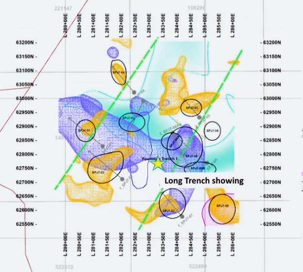
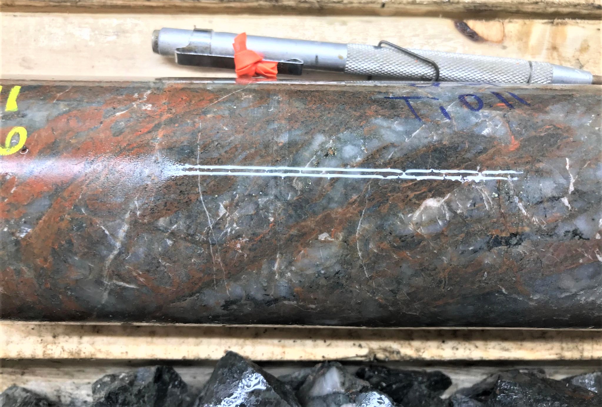
Powerline Area Long Trench Showing
Channel Sampling results from the Long Powerline Trench showing include:
- 25 g/t Au, 0.011% Co and 0.027% Ni over 13 metres
- 0.23 g/t Au, 0.008% Co and 0.019% Ni over 18 metres
Scadding Mine Area:
Scadding:
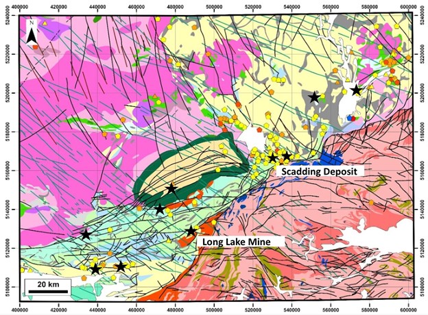
The historic Scadding Mine, located within our property, produced 29,000 oz of gold at a head grade of 7.2 g/t (OFR 5771). The Scadding Deposit gold mineralization of the Sudbury Gold District contrast with an orogenic gold discovery of the Surluga Deposit in the Wawa Gold Camp, Ontario
Gold associated with quartz veins with variable white mica and iron carbonate with pyrite and pyrrhotite (Si-K-CO2 – S alteration)
Scadding Deposit in the Sudbury Gold District- Gold associated with Fe-rich chlorite with variable magnetite, pyrite, pyrrhotite and minor to accessory chalcopyrite with (iron-sulfide alteration)
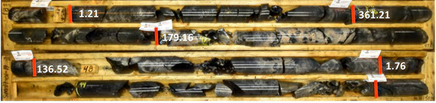
The Scadding Deposit has seen a considerable amount of exploration drilling (30,338 metres of diamong drilling by 7 operators) and many factors hindered the successful development of the property area:
- Atypical style of gold mineralization in a Canadian context
- Structural complexity of mineralized zones
- High uncertainty on the locations of historic collars
- Data processing and database mistakes
Nevertheless, since initiating exploration in the summer of 2018, our drilling results support the hypothesis that gold mineralization in the Scadding deposit is primarily controlled by a series of fold that are laterally distributed in a west to east corridor at least 500 metres wide.
During 2019/2020 our team drill tested 83 holes (~15,500m) and discovered mineralization beyond the historical Scadding Mine footprint.
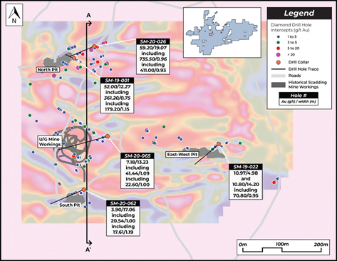

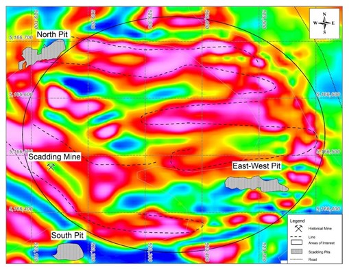
A high-resolution 3D IP survey was completed over the Scadding Deposit area by our exploration team which identified structures (folds) that control the emplacement and geometry, to depth, of the gold-bearing iron/chlorite-rich zones.
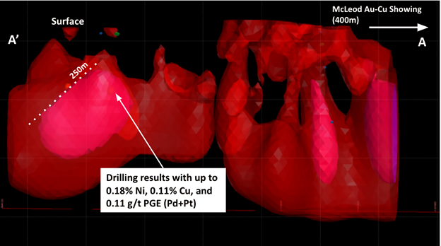
Jovan – Mcleod Area:
- The Jovan area within the eastern portion of our SPJ Property is located just 500m south of the past-producing Nortstar Mine, which produced 15,000 ounces of gold from 63,000 tonnes of ore grading 7.2 g/t Au and 0.9% Cu.*
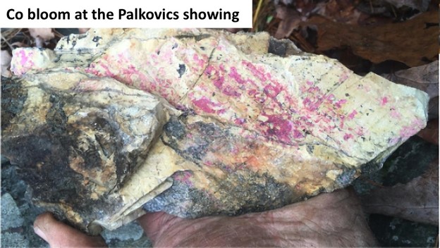
- Historical Drilling within the Jovan Area suggested a potential for sizeable polymetallic mineralization highlighted by grades of 6.78 g/t Au, 0.79% Cu, and 0.1% Co over a span of 0.3 metres within a broader mineralized envelope of 0.36 g/t Au, 0.06% Cu and 0.01% Co over 19.3m at the Palkovitcs Showing (Shown Below).*
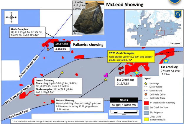
- Within the Jovan Area, our team has discovered several polymetallic showings that are distributed in two corridors of mineralization and deformation: Palkovics and Ess Creek. Both Palkovics and Ess Creek feature difference centers of mineralization.
Ess Creek Corridor:
- McLeod Au-Cu
- Au grades between 0.01 and 45.5 g/t and Cu grades between 0.023% and 0.39% in grab samples collected during the 2021 field season
- Au-Cu mineralization in semi-massive, fracture filling arsenopyrite-chalcopyrite-pyrite within albitized felsic intrusive unit and sediments
- Primarily fracture/joint controlled with possible mineralized lenses concentrated in shallowly plunging fold hinges
- Jovan Au-Co-Cu

*Assay Results are presented along core and channel sample length
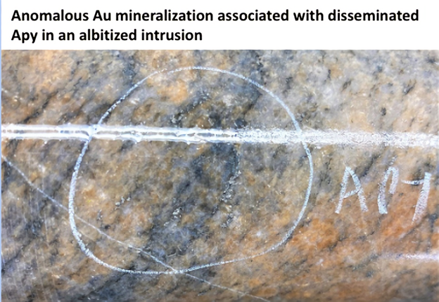
- Ess Creek Ag and Au
- Anomalous Au mineralization observed in associated with Apy disseminations in albitized tonalite
- 5 g/t Au over 1.26m (JV-21-086)*
- 19 g/t Au over 4.65m (JV-21-087)*
- Au mineralization observed in the Ess Creek Deformation Zone
- 0.85 g/t Au over 1.31m (JV-21-084)*
- Anomalous Au mineralization observed in associated with Apy disseminations in albitized tonalite
- Ess Creek Ni-(PGEs)
- Amp-(Ap)-Po-Py alteration and mineralization associated with Ni-(PGE-Cu) mineralization
- Exploration drilling demonstrated the association between Ni-Cu-PGE mineralization and the geophysical anomalies (low resistivity, high metal factor)


Po-Py alteration and mineralization associated with Ni-(PGE-Cu) mineralization
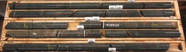
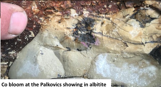
Palkovics Corridor:
- Palkovics Au-Co & Crerar Au-Co-Cu
- Au and Co mineralization overprinting Na alteration
- Mineralization associated with Cb alteration and Py mineralization
- As-Py associated with Au
- Co-Py associated with Co
- 0.88 g/t Au over 6.25m (JV-21-083)*
- Trends to the Crerar showing where grab sample contained up to 8.87 g/t Au and 2.96% Cu
*The reader is cautioned that the assay data is historical in nature, and the qualified person has not independently validated the accuracy of the historical results. The true width of the intersected zone of mineralization is unknown.
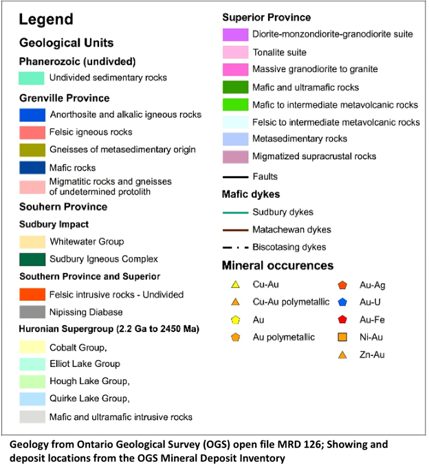
Geology of SPJ Property:
Location and Geological Setting
The SPJ project area historically has been affected by numerous tectonic and thermal events, which have enhanced the crustal permeability. Within our property we have evidence of two specific events that have created many episodes of precious and critical metal mineralization.
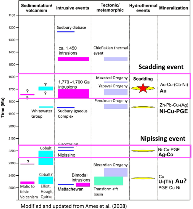
Nipissing Event:
- Ni-Cu-PGE mineralization
- Ag-Co mineralization (Cobalt Area)
- Magmatic Ni-Cu-PGE Mineralization
- Mineralized Nipissing Intrusions present on SPJ Property
- MDI database indicate different centers of Ni-Cu-(Au-PGE) mineralization
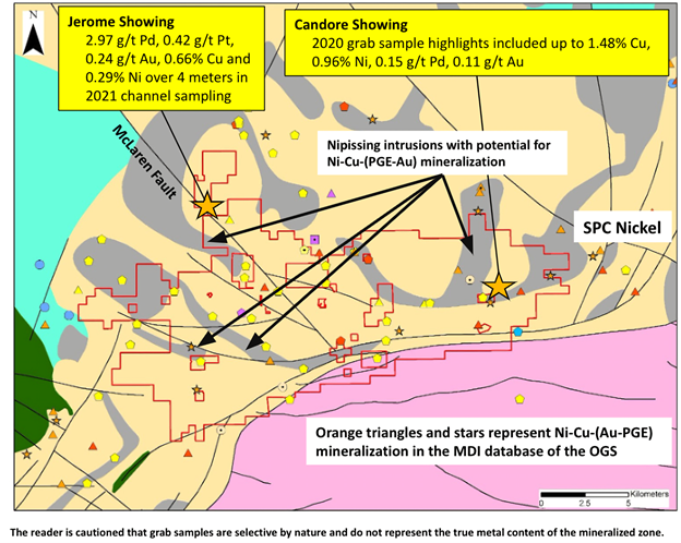
- Candore Showing – Evidence of magmatic Ni-Cu-PGE mineralization in the Nipissing sills of the SPJ Property
- Historical Drilling between 1955-2001 discovered mineralization that consists of semi-massive to massive sulphides – primarily pyrrhotite, with lesser chalcopyrite and minor pyrite occurring as disseminations and minor stringers
Jerome Showing – 2021 channel sampling results show disseminated chalcopyrite, pyrite, and pyrrhotite carrying prospective concentrations of Ni-Cu-PGE, associated with Nipissing diabase
Regional Examples of Nipissing Event – Ni-Cu-PGE mineralization
1 – James Property – SPC Nickel
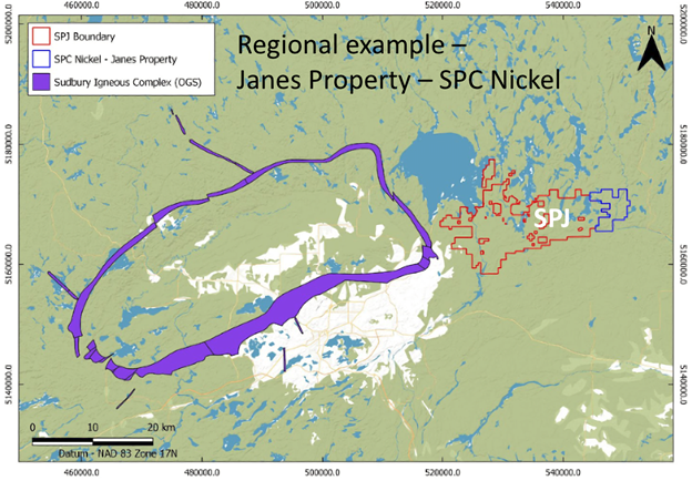
Ni-Cu-PGE mineralization identified on SPC property adjacent to BMK’s SPJ project
- Disseminated, 2. Massive, 3. Shear-hosted high-grade (likely remobilization during the Scadding event).
- 1) 2.71g/t PGM, 1.01% Cu, 0.27% Ni over 18.05m at 32.0m (DDH JR99 01)*
- 2) 1.51% Ni, 1.86% Cu, 1.79g/t PGM over 7.9m at 172.8m (DDH 69 08)*
- 3) 1,715g/t Pd, 17.25g/t Pt, 109.5g/t Au. 0.23% Cu, 0.23% Cu (grab)*
- Mineralization in the FW of a folded Nipissing Sill*
*The reader is cautioned that the above information is not necessarily indicative of comparable mineralization on BMK’s SPJ property
2- Shakespeare Project – Magna Mining (located 70km south-west of Sudbury)

Source : https://magnamining.com/portfolio_page/shakespeare/#sp-overview
M&I: 20.34 Mt @ 0.55% NiEq;
Inferred: 2.36 Mt @ 0.57% NiEq
Scadding Event
- Au-(Co-Cu) mineralization
- Ni-Cu-PGE mineralization
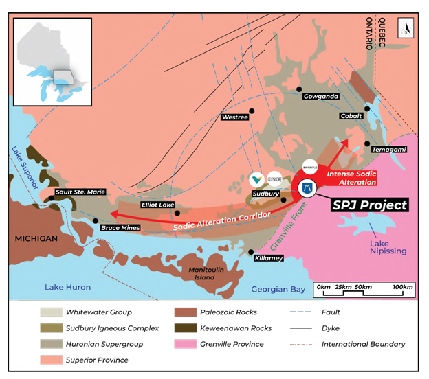
- Sodic Alteration extends from Bruce Mines to Temagami (Gates, 1991)
- Greatest intensity recognized so for is east of the Sudbury Igneous Complex, south and east of Lake Wanapitei
- Corresponds to the area of highest intensity of polymetallic gold mineralization
- Metamorphic sodic alteration zones described in the Grenville Front Tectonic Zone (Gates, 1991)

Scadding Event – Polymetallic Gold Mineralization